SkaMix2 operational map
This map displays the near real time locations of vessels and autonomous platforms during the SkaMix project. For now, it updates every 10 minutes. More improvements to come soon!
🔍 Instructions: click on the map for a lon-lat popup. Use the layers icon in the top right to select satellite imagery etc. Use the compass icon to measure distances and bearings. Zoom and full screen toggles are in the top left corner.
👋New! You can find EMODnet wirewalker-friendly depths and FTLE layers at the bottom of the layers list
Time since last page refresh:
Time since last location update
Refresh to update!
Data sources 📋
- Glider data Voice of the Ocean Foundation
- R/V Heicke & R/V Elisabeth Mann Borgese O2A https://o2a-data.de/documentation Koppe, R., Gerchow, P., Macario, A., Haas, A., Schäfer-Neth, C. and Pfeiffenberger, H. (2015): O2A: A Generic Framework for Enabling the Flow of Sensor Observations to Archives and Publications, OCEANS 2015 Genova. doi:10.1109/OCEANS-Genova.2015.7271657
- R/V Skagerak Postgres server operated by Skagerak Facility, University of Gothenburg
- Satellite products Copernicus Marine doi: https://doi.org/10.48670/moi-00154
- Norwegian SST forecast Meteorologisk institutt, Norway
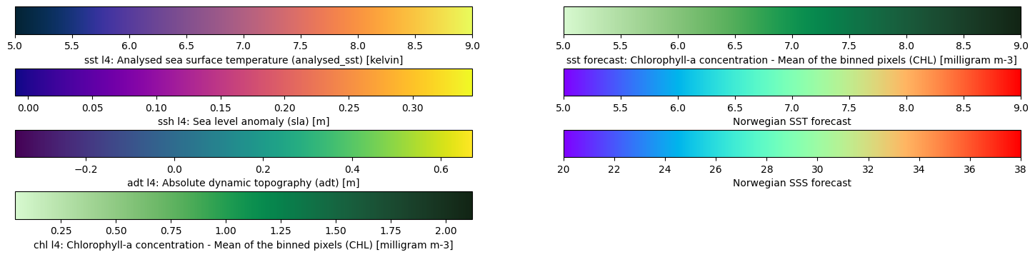
Satellite product info 🛰️
- sst_l4 variable: Analysed sea surface temperature (analysed_sst)
- sst_l3 variable: Sea surface subskin temperature (sea_surface_temperature)
- ssh_l4 variable: Sea level anomaly (sla)
- adt_l4 variable: Absolute dynamic topography (adt)
- chl_l4 variable: Chlorophyll-a concentration - Mean of the binned pixels (CHL)
- sst_forecast variable: Potential temperature (thetao)
- sss_forecast variable: Salinity (so)
Source code 🐍 https://github.com/voto-ocean-knowledge/SkaMixMap
Made under pressure in the Baltic by Callum Rollo and Grete Boskamp